Prag 3
Praha 3
Basisdaten
Staat :
Tschechien Tschechien
Region :
Hlavní město Praha
Gemeinde :
Praha
Fläche :
649 ha
Geographische Lage :
50° 5′ N , 14° 28′ O 50.084444444444 14.470277777778 Koordinaten: 50° 5′ 4″ N , 14° 28′ 13″ O
Einwohner :
72.507 (31. Dezember 2015)
Postleitzahl :
130 00
Verwaltung
Bürgermeister :
Michal Vronský (TOP 09 ) (Stand: 2022)
Adresse:
Havlíčkovo nám. 9/700
Website :
www.praha3.cz
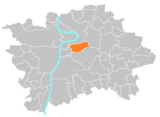
Prag 3 ist ein Verwaltungsbezirk der tschechischen Hauptstadt Prag . Der Bezirk liegt im Norden der Stadt. Prag 3 umfasst den überwiegenden Teil der Katastralgemeinde Žižkov und Teile von Vinohrady , Vysočany und Strašnice . Seit seiner Einrichtung im Jahr 1960 blieb das Gebiet des Bezirks unverändert. In Prag 3 liegt der Sankt Veitsberg (Vítkov).
Der Fernsehturm in Žižkov
Prag 1 |
Prag 2 |
Prag 3 |
Prag 4 (Prag 4, Kunratice ) |
Prag 5 (Prag 5, Slivenec ) |
Prag 6 (Prag 6, Lysolaje, Nebušice , Přední Kopanina , Suchdol ) |
Prag 7 (Prag 7, Troja ) |
Prag 8 (Prag 8, Březiněves , Ďáblice , Dolní Chabry ) |
Prag 9 |
Prag 10 |
Prag 11 (Prag 11, Křeslice , Šeberov , Újezd) |
Prag 12 (Prag 12, Libuš ) |
Prag 13 (Prag 13, Řeporyje ) |
Prag 14 (Prag 14, Dolní Počernice ) |
Prag 15 (Prag 15, Dolní Měcholupy, Dubeč, Petrovice, Štěrboholy ) |
Prag 16 (Radotín , Lipence , Lochkov , Velká Chuchle, Zbraslav ) |
Prag 17 (Řepy , Zličín ) |
Prag 18 (Letňany , Čakovice ) |
Prag 19 (Kbely , Satalice, Vinoř ) |
Prag 20 (Horní Počernice) |
Prag 21 (Újezd nad Lesy , Běchovice , Klánovice, Koloděje) |
Prag 22 (Prag 22, Benice, Kolovraty, Královice, Nedvězí)
The article is a derivative under the Creative Commons Attribution-ShareAlike License .
A link to the original article can be found here and attribution parties here
By using this site, you agree to the Terms of Use . Gpedia ® is a registered trademark of the Cyberajah Pty Ltd