Merri, Orne
Merri | |
|---|---|
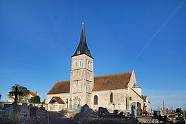 The church in Merri | |
 Merri  Merri | |
| Coordinates: 48°51′05″N 0°02′33″W / 48.8514°N 0.0425°W | |
| Country | France |
| Region | Normandy |
| Department | Orne |
| Arrondissement | Argentan |
| Canton | Argentan-2 |
| Intercommunality | Terres d'Argentan Interco |
| Government | |
| • Mayor (2020–2026) | Nadine Boisseau[1] |
Area 1 | 5.81 km2 (2.24 sq mi) |
| Population (2022)[2] | 151 |
| • Density | 26/km2 (67/sq mi) |
| Time zone | UTC+01:00 (CET) |
| • Summer (DST) | UTC+02:00 (CEST) |
| INSEE/Postal code | 61276 /61160 |
| Elevation | 62–171 m (203–561 ft) (avg. 97 m or 318 ft) |
| 1 French Land Register data, which excludes lakes, ponds, glaciers > 1 km2 (0.386 sq mi or 247 acres) and river estuaries. | |
Merri (French pronunciation: [mɛʁi] ⓘ) is a commune in the Orne department in north-western France.
Geography
The commune is made up of the following collection of villages and hamlets, L'Herbeyand Merri.[3]
The River Dives runs through the commune.[4]
Places of interest
- Camp de Bierre is an archaeological site dating back to the Neolithic era.[5] The main dry-stone wall of the site measures 32 metres across and is 7 metres in height.[6]
-
 Camp de Bierre
 -
 Monument aux morts in Merri


Notable People
- Jacqueline Pierreux - (1923 – 2005) a French film and television actress, is buried here.[7]
See also
References
- ^ "Répertoire national des élus: les maires" (in French). data.gouv.fr, Plateforme ouverte des données publiques françaises. 13 September 2022.
- ^ "Populations de référence 2022" (in French). The National Institute of Statistics and Economic Studies. 19 December 2024.
- ^ a b "Google Maps". Google Maps.
- ^ Sandre. "Fiche cours d'eau - La Dives (I1--0200)".
- ^ "Camp Celtique de Bière - Ancient Village or Settlement in France in Normandie:Orne (61)". The Megalithic Portal.
- ^ "Le Camp de Bierre MERRI : Normandy Tourism". Normandy Tourism, France.
- ^ "61 - PATRIMOINE FUNERAIRE DE L'ORNE : Etat des lieux - Cimetières de France et d'ailleurs". www.landrucimetieres.fr.
Wikimedia Commons has media related to Merri.
| Authority control databases: National |
|---|