Iosrael
Iosrael
| Pàirt de | An Ear Mheadhanach, West Asia, Àisia |
|---|---|
| Cur air cois | 14 dhen Chèitean 1948 |
| Name | ꠁꠎꠞꠣꠁꠟ |
| Ainm oifigeil | ישראל, دَوْلَة إِسْرَائِيل |
| Ainm dùthchasach | מְדִינַת יִשְׂרָאֵל, دَوْلَة إِسْرَائِيل |
| Ainm goirid | 🇮🇱, ישראל |
| Vocalized name | מְדִינַת יִשְׂרָאֵל, رِیاسَتِ اِسْرائِیل, دَوْلَة إِسْرَائِيل |
| Tar-sgrìobhadh IPA | ˈiːsɾɑɛl, ˈɪzreɪəl, jisʁaˈʔel |
| Participant in | War of Attrition, relations between Israel and Mercosur, "First Rain" Operation |
| Archives at | Israel State Archives |
| Ainmichte às dèidh | Land of Israel, Jacob |
| Stèidhichte le | David Ben-Gurion |
| Cànan oifigeil | Eabhra |
| Laoidh | Hatikvah |
| Motto | no value |
| Mòr-roinn | Àisia |
| Dùthaich | Iosrael |
| Prìomh-bhaile | Ierusalem |
| Roinn-tìde | Israel Standard Time, Israel Summer Time, Asia/Jerusalem, UTC+02:00, UTC+03:00 |
| Làrach | Southern Levant |
| Suidheachadh cruinn-eòlais | Fertile Crescent |
| Domhan-leud is -fhad | 31°0′0″N 35°0′0″E |
| Coordinates of easternmost point | 32°56′43″N 35°53′46″E |
| Coordinates of northernmost point | 33°19′58″N 35°46′5″E |
| Coordinates of southernmost point | 29°29′27″N 34°54′10″E |
| Coordinates of westernmost point | 31°13′11″N 34°16′3″E |
| Puing as àirde | Meron |
| Lowest point | Dead Sea |
| Basic form of government | parliamentary republic, unitary state |
| Oifis aig ceann-stàite | Ceann-suidhe Israeil |
| Ceannard na stàite | Isaac Herzog |
| Oifis aig ceann an riaghaltais | Prime Minister of Israel |
| Ceannard an riaghaltais | Benjamin Netanyahu |
| Has cabinet | cabinet of Israel |
| Executive body | cabinet of Israel |
| Legislative body | Knesset |
| Highest judicial authority | Israeli Supreme Court |
| Central bank | Bank of Israel |
| Ball de | Na Dùthchannan Aonaichte |
| Ideòlas poilitigeach | Zionism |
| Currency | new shekel |
| Location of formation | Independence Hall |
| Crìoch còmhla ri | Siria, Iòrdan, An Èipheit, Leabanon |
| Teacsa stéidheachaidh | Declaration of the Establishment of the State of Israel |
| Driving side | right |
| Electrical plug type | Europlug, Type H, BS 546 |
| Na bh’ann roimhe | Mandat na Palastain |
| Cuspair eòlais | Israel studies |
| Production statistics | olive |
| Described at URL | http://68k.news/index.php?section=nation&loc=IL&lang=HE |
| External data available at URL | http://www.cbs.gov.il/, https://www.cia.gov/library/publications/the-world-factbook/geos/is.html, https://www.oecd.org/israel/ |
| Hashtag | Israel, israel |
| Top-level Internet domain | .il, ישראל. |
| Bratach | flag of Israel |
| Gearradh-arm | Emblem of Israel |
| Official symbol | Calman cathaidh, Anemone coronaria, Canaan Dog, Olea europaea, Falafel |
| Geography of topic | geography of Israel |
| Feart | free country, Jewish and democratic state |
| History of topic | history of Israel |
| Official religion | Iùdhachd, Ioslam, Crìosdaidheachd, Druzism |
| Railway traffic side | left |
| Open data portal | data.gov.il |
| Economy of topic | economy of Israel |
| Demographics of topic | demographics of Israel |
| Mobile country code | 425 |
| Country calling code | +972 |
| Trunk prefix | 0 |
| Emergency phone number | 100, 101, 102 |
| GS1 country code | 729 |
| Licence plate code | IL |
| Maritime identification digits | 428 |
| Caractar Unicode | 🇮🇱 |
| Category for honorary citizens of entity | Category:Honorary citizens from Israel |
| Category for maps or plans | Category:Maps of Israel |
Is e dùthaich bheag ann an Àisia a tha ann an Iosrael [1][2][3][4] neo Israel, [5][6][7][8] (Eabhra: יִשְרָאֵל, Yisra'el; Arabais: إسرائيل, Isrā'īl), ainm oifigeil: Stàit Iosrael. Tha crìochan aice san ear le Iòrdan, sa tuath le Leabanon, san iar-dheas leis an Èipheit agus san ear-thuath leis an t-Siria. 'S e Iùdhaich a tha ann an cuid as motha de na daoine.
Eachdraidh
Bha Iosrael na phàirt Impireachd nan Otomanach ro 1922.
Dealbhan
-
 Fàsach Judea
 -
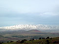 Mount Hermon fon t-sneachda
 -
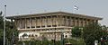 An Knesset, Pàrlamaid Iosralach


Daoine ainmeil
Aistean cho-ceangailte
Iomraidhean
- ↑ Am Faclair Beag
- ↑ Feuch Facal, Gairm (1995), ISBN 1-871901-39-1
- ↑ Dùthchannan ag SMO
- ↑ Am Faclair Gàidhlig-Beurla, Colin Mark, foillsichte aig Routledge, Lunnainn (2004), ISBN 0-415-29761-3
- ↑ Map-balla an t-Saoghail, Stòrlann Nàiseanta (2003), ISBN 0007692714
- ↑ An Tuil: Anthology of 20th-century Scottish Gaelic Verse, duilleag 678
- ↑ Brìgh nam Facal, Faclair Ùr don Bhun-sgoil (deas. Cox, Richard A.V.) - ISBN 0-903204-21-5
- ↑ Atlas Sgoile Oxford le Stòrlann Nàiseanta, Oxford University Press (2010)