Connecticut
| State of Connecticut | |||||||||||
| |||||||||||
| Basa resmi | none (de facto English) | ||||||||||
| Démonim | Connecticuter or Connecticutian[1] | ||||||||||
| Ibukutha | Hartford | ||||||||||
| Kutha paling gedhé | Bridgeport[2] | ||||||||||
| metro area paling gedhé | Hartford Metro Area[3] | ||||||||||
| Area | Ranking 48th ing AS | ||||||||||
| - Total | 5,543[4] sq mi (14,356 km²) | ||||||||||
| - Jembar | 70 miles (113 km) | ||||||||||
| - Dawa | 110 miles (177 km) | ||||||||||
| - % banyu | 12.6 | ||||||||||
| - Garis lintang | 40°58′ N to 42°03′ N | ||||||||||
| - Garis bujur | 71°47′ W to 73°44′ W | ||||||||||
| Populasi | Rangking 29th ing AS | ||||||||||
| - Total | 3,405,565[4] | ||||||||||
| - Kapadhetan | 702.9/sq mi 271.40/km² (4th in the US) | ||||||||||
| - Median income | $55,970 (4th) | ||||||||||
| Elevasi | |||||||||||
| - Titik paling dhuwur | South slope of Mount Frissell[5] Note: The peak of Mount Frissell is in Massachusetts 2,380 ft (726 m) | ||||||||||
| - Mean | 500 ft (152 m) | ||||||||||
| - Titik paling cendhèk | Long Island Sound 0 ft (0 m) | ||||||||||
| Mlebu Union | 9 Januari, 1788 (5th) | ||||||||||
| Gubernur | M. Jodi Rell (R) | ||||||||||
| Lètnan Gubernur | Michael Fedele (R) | ||||||||||
| Senator | Christopher Dodd (D) Joe Lieberman (ID) | ||||||||||
| Delegasi Konggrès | List | ||||||||||
| Zona wektu | Eastern: UTC-5/-4 | ||||||||||
| Cekakan | CT. Conn. US-CT | ||||||||||
| Situs web | www.ct.gov | ||||||||||

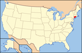
Connecticut (IPA: /kəˈnɛtɪkət/)[6] iku sawijining praja ing Amérika Sarékat sing dumunung ing wewengkon New England ing sisih lor-wétan. Praja iki wewatesan karo New York ing sisih kulon lan kidul, karo (Long Island déning sagara), Massachusetts ing sisih lor, lan Rhode Island ing sisih wétan.
Rujukan
- ↑ Q. What Do You Call Someone From Connecticut? About.com: Hartford. Accessed 2008-4-24
- ↑ Population Estimates for All Places: 2000 to 2006: Connecticut SUB-EST2006-04-09.xls. United States Census Bureau. Last accessed 2007-10-16.
- ↑ State Data from the State and Metropolitan Area Data Book: 2006. United States Census Bureau. Last accessed 2007-10-16.
- ↑ a b GCT-PH1-R. Population, Housing Units, Area, and Density (geographies ranked by total population): 2000. United States Census Bureau. Last accessed 2007-02-20.
- ↑ "Elevations and Distances in the United States". U.S Geological Survey. 29 April 2005. Dibukak ing 2006-11-03.
- ↑ "Connecticut - Definitions from Dictionary.com". Dibukak ing 2007-09-17.
Pranala njaba
| Andharan saka Wikibausastra | |
| Médhia saka Commons | |
| Warta saka Wikinews | |
| Cuplikan saka Wikiquote | |
| Tèks saka Wikisource | |
| Buku tèks saka Wikibooks | |
| Matèri sinau saka Wikiversity | |
Pamaréntah
- State of Connecticut - Official state website
- Energy Data & Statistics for Connecticut- From the U.S. Department of Energy
- Connecticut State Databases - Annotated list of searchable databases produced by Connecticut state agencies and compiled by the Government Documents Roundtable of the American Library Association.
- Connecticut State Register & Manual - updated annually
- Directory of Web sites of Connecticut towns and cities
Turisme
- CTVisit.com - Official state tourism website

Wikiplesir duwé panuntun plesir ngenani Connecticut. Sajarah
- Connecticut Society of Genealogists (Est. 1968)
- Connecticut Historical Society
- USGS real-time, geographic, and other scientific resources of Connecticut
- U.S. Census Bureau
- Connecticut State Facts
- History topics timeline of Connecticut 1738-1838
Organisasi lan bisnis
- Connecticut Junior Chamber (Jaycees)
- Connecticut Newspapers
- Connecticut Business & Industry Association
- The Connecticut Business Hall Of Fame
Cithakan:Nagara pérangan Connecticut


