ꯑꯃꯦꯖꯣꯟ ꯇꯨꯔꯦꯜ
| ꯑꯃꯦꯖꯣꯟ ꯇꯨꯔꯦꯜ | |
|---|---|
 ꯑꯃꯥꯓꯣꯟ ꯇꯨꯔꯦꯜ ꯏꯟꯗꯤꯌꯥꯅꯥ ꯃꯅꯥꯛ, ꯄꯦꯔꯨꯗ | |
 ꯑꯃꯥꯓꯣꯟ ꯇꯨꯔꯦꯜ ꯑꯃꯁꯨꯡ ꯃꯁꯤꯒꯤ ꯏꯊꯩ ꯈꯣꯡꯕꯥꯟꯁꯤꯡ | |
| ꯌꯦꯜꯍꯧ ꯃꯃꯤꯡ | ꯑꯃꯥꯓꯣꯅꯥꯁ |
| Location | |
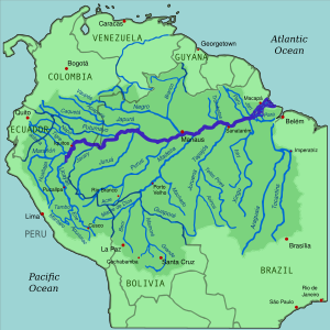
| ꯂꯩꯄꯥꯛ | ꯕꯔꯥꯓꯤꯜ, ꯀꯣꯂꯣꯝꯕꯤꯌꯥ, ꯄꯦꯔꯨ |
| City | Iquitos (Peru); Leticia (Colombia); Tabatinga (Brazil); Tefé (Brazil); Itacoatiara (Brazil) Parintins (Brazil); Óbidos (Brazil); Santarém (Brazil); Almeirim (Brazil); Macapá (Brazil); Manaus (Brazil) |
| Physical characteristics | |
| ꯃꯆꯤꯟ | Atlantic Ocean |
⁃ location | Brazil |
⁃ coordinates | 0°42′28″N 50°5′22″W / 0.70778°N 50.08944°Wꯀꯣꯑꯣꯔꯗꯤꯅꯦꯠꯁ: 0°42′28″N 50°5′22″W / 0.70778°N 50.08944°W[꯱] |
⁃ elevation | ꯰ m (꯰ ft) |
| ꯑꯁꯥꯡꯕ | ꯷,꯰꯰꯰ ꯀꯤm (꯴,꯳꯰꯰ mi)[n ꯱] |
| ꯇꯣꯔꯕꯥꯟ ꯆꯥꯎꯕꯒꯤ ꯆꯥꯡ | ꯷꯰,꯵꯰,꯰꯰꯰ ꯀꯤm2 (꯷.꯵꯹×꯱꯰꯱꯳ sq ft)[꯲] |
| Basin features | |
| ꯇꯨꯔꯤꯟ | |
| ⁃ left | Marañón, Napo, Japurá/Caquetá, Rio Negro/Guainía, Putumayo, Trombetas |
| ⁃ right | Ucayali, Javary, Juruá, Purús, Madeira, Tapajós, Xingu |

ꯑꯦꯃꯦꯖꯣꯟ ꯇꯨꯔꯦꯜ ꯅꯠꯇ꯭ꯔꯒ ꯑꯃꯦꯖꯣꯟ ꯇꯨꯔꯦꯜ ꯅꯠꯇ꯭ꯔꯒ ꯑꯃꯖꯣꯟ ꯇꯨꯔꯦꯜ (UK: /ˈæməzən/, US: /ˈæməzɒn/; ꯁ꯭ꯄꯦꯅꯤꯁ ꯑꯃꯁꯨꯡ [Amazonas] error: {lang-xx}: unrecognized language code: pt (help)) ꯈꯥ ꯑꯃꯦꯔꯤꯀꯥꯗ ꯂꯩꯕ ꯑꯁꯤꯅꯥ ꯈꯨꯋꯥꯏꯗꯒꯤ ꯆꯥꯎꯕ ꯇꯨꯔꯦꯜ ꯑꯣꯏꯔꯤ ꯫[꯲][꯶]
ꯃꯇꯦꯡ ꯂꯧꯐꯝ
ꯂꯧꯔꯛꯐꯝꯁꯤꯡ ꯎꯠꯄ
- ↑ The length of the Amazon River is usually said to be "at least" ꯶,꯴꯰꯰ ꯀꯤm (꯴,꯰꯰꯰ mi),[꯲] but reported values lie anywhere between ꯶,꯲꯷꯵ ꯀꯤm (꯳,꯸꯹꯹ mi) and ꯷,꯰꯲꯵ ꯀꯤm (꯴,꯳꯶꯵ mi).[꯳] The length measurements of many rivers are only approximations and differ from each other because there are many factors that determine the calculated river length, such as the position of the geographical source and the mouth, the scale of measurement, and the length measuring techniques (for details see also List of rivers by length).[꯳][꯴]