Labrador Sea
| Labrador Sea |
|---|
 Past sunset at Labrador Sea, off the coast o Paamiut, Greenland |
 |
| Coordinates | 61°N 56°W / 61°N 56°W / 61; -56 (Labrador Sea)Coordinates: 61°N 56°W / 61°N 56°W / 61; -56 (Labrador Sea) |
|---|
| Teep | Sea |
|---|
| Basin kintras | Canadae, Greenland |
|---|
|
|---|
| Max. lenth | c. 1,000 km (621 mi) |
|---|
| Max. weenth | c. 900 km (559 mi) |
|---|
| 841,000 km2 (324,700 sq mi) |
| Average deepth | 1,898 m (6,227 ft) |
|---|
| Max. deepth | 4,316 m (14,160 ft) |
|---|
|
|---|
| References | [1][2] |
|---|
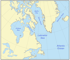
The Labrador Sea (French: mer du Labrador) is an airm o the North Atlantic Ocean atween the Labrador Peninsula an Greenland.
References
|
|---|
| Arctic Ocean |
- Amundsen Gulf
- Barents Sea
- Beaufort Sea
- Bering Strait
- Chukchi Sea
- East Siberian Sea
- Fram Strait
- Greenland Sea
- Gulf o Boothia
- Kara Sea
- Kara Strait
- Laptev Sea
- Lincoln Sea
- Prince Gustav Adolf Sea
- Pechora Sea
- Wandel Sea
- White Sea
|
|---|
| Atlantic Ocean | |
|---|
| Indie Ocean | |
|---|
| Paceefic Ocean |
- Arafura Sea
- Bali Sea
- Banda Sea
- Bering Sea
- Bismarck Sea
- Bohai Sea
- Bohol Sea
- Camotes Sea
- Celebes Sea
- Ceram Sea
- Chilean Sea
- Coral Sea
- East Cheenae Sea
- Flores Sea
- Gulf o Alaska
- Gulf o Californie
- Gulf o Carpentaria
- Gulf o Fonseca
- Gulf o Thailand
- Gulf o Tonkin
- Halmahera Sea
- Java Sea
- Koro Sea
- Mar de Grau
- Makassar Strait
- Molucca Sea
- Moro Gulf
- Philippine Sea
- Salish Sea
- Savu Sea
- Sea o Japan
- Sea o Okhotsk
- Seto Inland Sea
- Sibuyan Sea
- Solomon Sea
- Sooth Cheenae Sea
- Sulu Sea
- Tasman Sea
- Visayan Sea
- Yellow Sea
|
|---|
| Soothren Ocean |
- Amundsen Sea
- Bellingshausen Sea
- Cooperation Sea
- Cosmonauts Sea
- Davis Sea
- D'Urville Sea
- King Haakon VII Sea
- Lazarev Sea
- Riiser-Larsen Sea
- Mawson Sea
- Ross Sea
- Scotia Sea
- Somov Sea
- Weddell Sea
|
|---|
| Laundlocked seas | |
|---|

