Gauting
Gauting | |
|---|---|
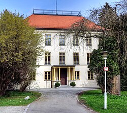 Fußberg Castle | |
 Coat of arms | |
Location of Gauting within Starnberg district 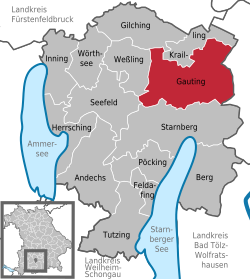 | |
 Gauting  Gauting | |
| Coordinates: 48°04′04″N 11°22′26″E / 48.06778°N 11.37389°E | |
| Country | Germany |
| State | Bavaria |
| Admin. region | Upper Bavaria |
| District | Starnberg |
| Subdivisions | 11 districts |
| Government | |
| • Mayor | Brigitte Kössinger (CSU) |
| Area | |
| • Total | 50.38 km2 (19.45 sq mi) |
| Elevation | 564 m (1,850 ft) |
| Population (2022-12-31)[1] | |
| • Total | 21,276 |
| • Density | 420/km2 (1,100/sq mi) |
| Time zone | UTC+01:00 (CET) |
| • Summer (DST) | UTC+02:00 (CEST) |
| Postal codes | 82131 |
| Dialling codes | 089 |
| Vehicle registration | STA |
| Website | www |
Gauting is a municipality in the district of Starnberg in Upper Bavaria in Germany. It is on the river Würm and is 17 kilometres (11 miles) southwest of Munich.
Districts
Gauting has 11 districts:
- Buchendorf
- Gauting
- Grubmühl
- Hausen
- Königswiesen
- Mitterwies
- Oberbrunn
- Oberwies
- Reismühl
- Stockdorf
- Unterbrunn
References
- ↑ Genesis Online-Datenbank des Bayerischen Landesamtes für Statistik Tabelle 12411-003r Fortschreibung des Bevölkerungsstandes: Gemeinden, Stichtag (Einwohnerzahlen auf Grundlage des Zensus 2011) .
Other websites
![]() Media related to Gauting at Wikimedia Commons
Media related to Gauting at Wikimedia Commons
- Official website of the municipality of Gauting (in German)
Towns and municipalities in Starnberg district | ||
|---|---|---|
| International | |
|---|---|
| National | |
| Geographic | |