Havelland
Havelland | |
|---|---|
 Flag  Coat of arms | |
 | |
| Coordinates: 52°38′N 12°38′E / 52.633°N 12.633°E | |
| Country | Germany |
| State | Brandenburg |
| Capital | Rathenow |
| Area | |
| • Total | 1,717 km2 (663 sq mi) |
| Population (31 December 2022)[1] | |
| • Total | 169,334 |
| • Density | 99/km2 (260/sq mi) |
| Time zone | UTC+01:00 (CET) |
| • Summer (DST) | UTC+02:00 (CEST) |
| Vehicle registration | HVL |
| Website | http://www.havelland.de |
Havelland is a district in Brandenburg, Germany.
History
The district was established in 1993 by joining the old districts of Nauen and Rathenow.
Havelland is the name for the regions on the banks of the Havel river between the city of Berlin and the Elbe river. This region also includes the cities of Brandenburg and Potsdam, that are not part of the district. The Havelland district mainly consists of the areas north of the Havel river.
Coat of arms
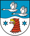
|
The red eagle is the heraldic animal of Brandenburg. The head of the eagle is part of the coat of arms of Rathenow. The swan is often used as a symbol for the Havelland region. |
Towns and municipalities
| Amt-free towns | Ämter | |
|---|---|---|
|
1. Friesack
2. Nennhausen
|
3. Rhinow
|
| 1seat of the Amt; 2town | ||
References
- ↑ "Bevölkerungsentwicklung und Bevölkerungsstandim Land Brandenburg Dezember 2022" (PDF). Amt für Statistik Berlin-Brandenburg (in German). June 2023.
Other websites
- Official website (in German)
- Touristical website
| Urban districts | |
|---|---|
| Rural districts | |
| International | |
|---|---|
| National | |