Interstate 64 (Kentucky)
Interstate 64 | |
|---|---|
 | |
| Route information | |
| Length | 953.74 mi[1][2] (1,534.90 km) |
| Existed | 1961–present |
| NHS | Entire route |
| Major junctions | |
| West end | |
| East end | |
| Location | |
| Country | United States |
| Highway system | |

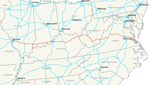
Interstate 64 is a long Interstate Highway in the United States. It goes from Wentzville, Missouri east to Chesapeake, Virginia. The route is 953.74 miles (1,534.90 km) long.[1][2]
References
- ↑ 1.0 1.1 DeLorme Street Atlas USA software. Toggle Measure Tool and Driving Directions for Missouri Milage.
- ↑ 2.0 2.1 FHWA Route Log and Finder List: Table 1
| Signed | |
|---|---|
| Unsigned | |
| Lists | |
Major Interstates highlighted | |
| KML file (edit • help)
|