Leidersbach
Leidersbach | |
|---|---|
 Coat of arms | |
Location of Leidersbach within Miltenberg district 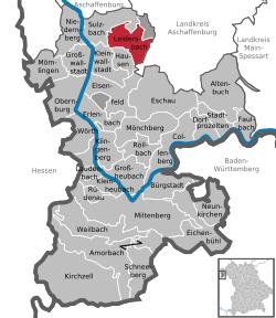 | |
 Leidersbach  Leidersbach | |
| Coordinates: 49°54′N 9°13′E / 49.900°N 9.217°E | |
| Country | Germany |
| State | Bavaria |
| Admin. region | Unterfranken |
| District | Miltenberg |
| Subdivisions | 4 Ortsteile |
| Government | |
| • Mayor (2017–23) | Michael Schüßler[1] |
| Area | |
| • Total | 19.81 km2 (7.65 sq mi) |
| Elevation | 196 m (643 ft) |
| Population (2022-12-31)[2] | |
| • Total | 4,795 |
| • Density | 240/km2 (630/sq mi) |
| Time zone | UTC+01:00 (CET) |
| • Summer (DST) | UTC+02:00 (CEST) |
| Postal codes | 63849 |
| Dialling codes | 06028, 06092 |
| Vehicle registration | MIL |
| Website | www.leidersbach.de |
Leidersbach is a community in the Miltenberg district in the Lower Franconia region in Bavaria, Germany.
Geography
Place
Leidersbach is about 10 km south of Aschaffenburg in the Spessart.
Neighbouring communities
From the north, clockwise: Forst Hohe Wart (gemeindefreies Gebiet), Mespelbrunn, Heimbuchenthal, Hausen, Kleinwallstadt, Sulzbach am Main.
Subdivisions
Leidersbach's Ortsteile are Leidersbach, Ebersbach, Roßbach and Volkersbrunn.
Combinations
On 1 January 1972, the formerly self-administering communities of Leidersbach, Ebersbach, Roßbach and Volkersbrunn combined into a new unitary community of Leidersbach.
References
- ↑ Liste der ersten Bürgermeister/Oberbürgermeister in kreisangehörigen Gemeinden, Bayerisches Landesamt für Statistik, accessed 19 July 2021.
- ↑ Genesis Online-Datenbank des Bayerischen Landesamtes für Statistik Tabelle 12411-003r Fortschreibung des Bevölkerungsstandes: Gemeinden, Stichtag (Einwohnerzahlen auf Grundlage des Zensus 2011) .
Other websites
Wikimedia Commons has media related to Leidersbach.
Towns and municipalities in Miltenberg (district) | ||
|---|---|---|
|  | |
| International | |
|---|---|
| National | |