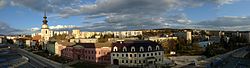
Myjava
Myjava | |
|---|---|
Town | |
 | |
 Coat of arms | |
 Myjava Location of Myjava in the Trenčín Region 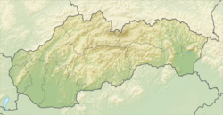 Myjava Myjava (Slovakia) | |
| Coordinates: 48°44′57″N 17°33′52″E / 48.74917°N 17.56444°E | |
| Country | Slovakia |
| Region | Trenčín |
| District | Myjava |
| Founded | 1586 |
| Government | |
| • Mayor | Pavel Halabrín |
| Area | |
| • Total | 48.54 km2 (18.74 sq mi) |
| (2022) | |
| Elevation | 313[2] m (1,027[2] ft) |
| Population | |
| • Total | 10,705 |
| • Density | 220/km2 (570/sq mi) |
| Time zone | UTC+1 (CET) |
| • Summer (DST) | UTC+2 (CEST) |
| Postal code | 907 01[2] |
| Area code | +421 34[2] |
| Car plate | MY |
| Website | www.myjava.sk |
Myjava (German: Miawa; Hungarian: Miava) is a town in the Trenčín Region in Slovakia. About 10,500 people live there.
References
- ↑ Statistical Office of the Slovak Republic (www.statistics.sk). "Hustota obyvateľstva - obce". www.statistics.sk. Retrieved 2024-02-08.
- ↑ 2.0 2.1 2.2 2.3 "Základná charakteristika". www.statistics.sk (in Slovak). Statistical Office of the Slovak Republic. 2015-04-17. Retrieved 2022-03-31.
- ↑ Statistical Office of the Slovak Republic (www.statistics.sk). "Počet obyvateľov podľa pohlavia - obce (ročne)". www.statistics.sk. Retrieved 2024-02-08.
Other websites
Wikimedia Commons has media related to Myjava.
- Official website (in Slovak)
| International | |
|---|---|
| National | |
| Geographic | |