Robinson projection
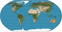
The Robinson Projection is a compromise between accuracy and the readability of the map on a flat surface. It shows the poles as lines, which accurately shows the high altitude lands and water to land ratio.
The Robinson Projection is a compromise between accuracy and the readability of the map on a flat surface. It shows the poles as lines, which accurately shows the high altitude lands and water to land ratio.