Stettfeld
Stettfeld | |
|---|---|
 Town hall (left), rectory (right) with the Church of the Assumption of the Virgin Mary in the back | |
 Coat of arms | |
Location of Stettfeld within Haßberge district 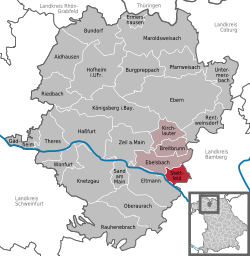 | |
 Stettfeld  Stettfeld | |
| Coordinates: 49°58′N 10°43′E / 49.967°N 10.717°E | |
| Country | Germany |
| State | Bavaria |
| Admin. region | Unterfranken |
| District | Haßberge |
| Municipal assoc. | Ebelsbach |
| Government | |
| • Mayor (2020–26) | Alfons Hartlieb[1] (CSU) |
| Area | |
| • Total | 11.16 km2 (4.31 sq mi) |
| Elevation | 240 m (790 ft) |
| Population (2022-12-31)[2] | |
| • Total | 1,118 |
| • Density | 100/km2 (260/sq mi) |
| Time zone | UTC+01:00 (CET) |
| • Summer (DST) | UTC+02:00 (CEST) |
| Postal codes | 96188 |
| Dialling codes | 09522 |
| Vehicle registration | HAS |
| Website | vg-ebelsbach.de |
Stettfeld is a municipality in Haßberge in Bavaria in Germany.
References
- ↑ Liste der ersten Bürgermeister/Oberbürgermeister in kreisangehörigen Gemeinden, Bayerisches Landesamt für Statistik, 15 July 2021.
- ↑ Genesis Online-Datenbank des Bayerischen Landesamtes für Statistik Tabelle 12411-003r Fortschreibung des Bevölkerungsstandes: Gemeinden, Stichtag (Einwohnerzahlen auf Grundlage des Zensus 2011) .
Towns and municipalities in Haßberge (district) | ||
|---|---|---|
 | ||
| International | |
|---|---|
| National | |